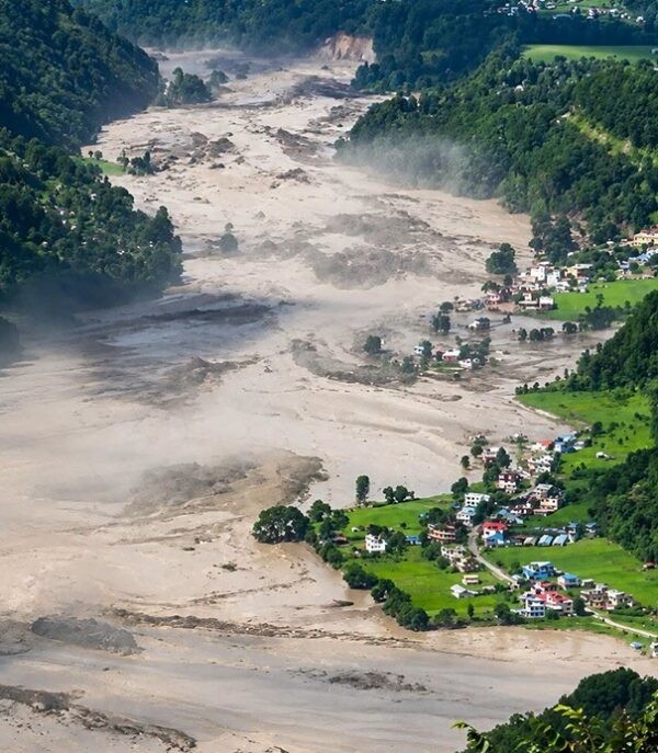
The recent Bhotekoshi‑Trishuli flood near the China‑Nepal border, which officials have described as a “mountain tsunami,” occurred while glaciers across the Hindu Kush Himalaya (HKH) are melting rapidly. The event coincides with the continued accelerated retreat of ice in the region.
Extreme events such as the catastrophic flood are no longer isolated anomalies; they signal a broader regional climate crisis in the fragile mountain region.
The translation of Earth‑observation data for the Hindu Kush‑Karakoram‑Himalaya (HKH) into actionable regional preparedness is an urgent requirement for climate action.
The August 26 flood showed how difficult it is to anticipate some of these risks in advance.
Scientific assessments and satellite images confirm that a massive rock‑ice avalanche collapsed into the Chhochen Khola, triggering a cascading flood of water, mud and debris that entered the Lhende Khola and continued downstream.
This disaster was a human tragedy, with more than 1,400 people dead and some 6,000.
The flood that hit on 26 August 2026, traced to a failure zone on Mount Langtang Lirung, devastated the Trishuli valley. Fertile lands in the Trishuli valley were washed away, millions of tonnes of carbon credits were destroyed and the economic damage was assessed at billions of dollars.
Image from Google Earth.[/caption] The impact was not confined to Nepal.
The “mountain tsunami” destroyed Gyirong Port, the principal border crossing for the movement of people and trade goods from Nepal into China.
Chinese authorities have reported that more than 40 people have been confirmed dead and that over 50 individuals remain missing.
Districts along the India-Nepal border were also put on heightened alert.
The Indian National Disaster Response Force (NDRF) deployed teams, and authorities urged residents of low‑lying areas to relocate to safer locations.
And Bihar is currently dealing with a much wider flood situation.
By 27 September, monsoon‑driven flooding had killed at least 56 people in India, and a further 14 fatalities were reported in Nepal.
The water levels of several rivers—namely the Ganga, Gandak, Koshi, Budhi Gandaki and Bagmati—have risen above danger thresholds at multiple locations.
Other South Asian countries are experiencing similar extreme climate events – floods and inundation.
Pakistan’s National Disaster Management Authority, the country’s disaster agency, reports that 199 deaths have been recorded since the rainfall began on 26 June of this year.
In July, more than one million people were stranded across seven districts in Bangladesh after several days of heavy rain.
The events of 2026 are not an aberration.
The flood‑risk map featured in the World Risk Report 2025 ranks Bangladesh, Pakistan and India among the world’s highest‑risk nations for flooding. The accompanying global flood‑risk map highlights these three countries as part of the four nations with the greatest exposure to flood hazards.
A map from the World Risk Report 2025, produced by Bündnis Entwicklung Hilft and IFHV, illustrates the situation. It is also worth noting that the events are occurring in a region where per‑capita greenhouse‑gas emissions are well below the global average of 6.4 tonnes of CO₂‑equivalent per person, with India at 2.5 tonnes, Pakistan at 1.0 tonne and Bangladesh at 0.8 tonnes.
The issue highlights a broader concern about climate inequality, noting that nations that have contributed relatively little to global greenhouse‑gas emissions are nonetheless confronting some of the most severe climate risks.
The impact of the floods – encompassing the events of August 26 as well as the earlier inundations – endures long after the waters have receded.
Repeated flooding continues to damage crops, homes, infrastructure, commerce and local economies, making it increasingly difficult for families to recover from successive losses.
Such conditions may render farming and other local livelihoods increasingly unsustainable over time, compelling affected individuals to choose migration as a result of heightened vulnerability.
A study conducted by the World Bank estimated that South Asia may see approximately 40 million internal climate migrants by the year 2050.
Is it possible to mitigate the damage through information sharing?
That’s been a topic of much discussion since the August floods hit Nepal.
Integrated Earth observations—including visual, thermal and synthetic‑aperture‑radar (SAR) remote sensing—combined with localized field surveys are documenting widespread cryospheric and geomorphic transformation across the Hindu Kush Himalaya (HKH) region. The data demonstrate that the cryosphere and landforms throughout the broader HKH are undergoing extensive change.
Satellite observations and on‑the‑ground monitoring confirm that glaciers across the Himalayas are undergoing continuous mass loss, with ice thickness decreasing by roughly half a metre each year. The same data show a broad lowering of the snowline and a reduction in overall snow cover.
River flows are typically stable, but some rivers show a temporary rise in discharge as a result of glacial ice melt.
ICIMOD’s 2026 assessment reports that glaciers throughout the Hindu Kush‑Karakoram‑Himalaya (HKH) region are now losing ice at approximately double the rate recorded before the year 2000.
A study of glaciers in the Everest region has found that debris‑covered ice bodies can undergo pronounced thinning, with surface elevations dropping by as much as 1.56 metres per year, and a concurrent slowdown in glacier flow.
Recent research indicates that the human‑populated area at Everest Base Camp is experiencing a higher surface‑warming rate than the adjacent unpopulated sections of the Khumbu glaciers, which constitute a major source of the Koshi River system.
The widespread decay of the cryosphere is destabilising adjacent slopes, as thawing permafrost and the degradation of paraglacial moraines increase susceptibility to catastrophic rock‑ice avalanches and complex hazard chains.
The flood on 26 August was triggered when an ice‑rock slope on the northern face of Mount Langtang Lirung collapsed, dumping material into the Chhochen Khola and Lhende Khola.
The collapse generated seismic energy comparable to a magnitude‑5.2 earthquake and developed into a destructive debris flow that surged downstream, crossing Nepal and entering both China and India.
Field observations and small‑scale studies remain limited in the Hindu Kush Himalaya (HKH) because of logistical challenges, resource constraints and the risks associated with fieldwork. Efforts are now focused on bridging this observation gap by linking satellite data, sensor networks and local communities.
Consequently, monitoring depends largely on Earth‑observation satellites and remote‑sensing techniques, while long‑term ground measurements of glacier mass balance, snow and other cryospheric variables remain limited.
Cloud cover, steep terrain, and limited ground validation further constrain even satellite observations.
A study found that the number of glacial lakes in Nepal, as well as their total surface area, increased between 1977 and 2017.
However, satellite-based inventories mainly capture such lakes’ extent and change.
Gauging lake depth, volume, dam condition, and hydrological behavior often requires field measurements or higher-resolution observations.
Major gaps remain in monitoring remote glaciers, snowfields, glacial lakes, unstable terrain, and headwater rivers.
The lack of data limits hazard forecasting, water resource assessments, and long-term mountain planning.
Addressing these gaps will require bringing different forms of observation together.
Integrating multi-tiered Earth observations would create a comprehensive framework for monitoring dynamic cryospheric hazards across Nepal and the Hindu Kush Himalaya (HKH) region.
Although satellite, SAR, and DEM data provide strong coverage for tracking glacier loss across broad areas, tools such as UAVs, CORS, and automated weather stations offer significantly greater detail at specific sites.
These tools help to monitor slope instability, ice movement and hydrometeorological conditions.
Complementing these technical solutions, local community observations contribute crucial real-time contextual validation during sudden disaster events.
Recent scientific assessments emphasize that bridging diverse inputs requires common geodetic reference frames, standardized data protocols, and centralized open-access platforms—such as Mountain GeoPortal. These tools enable agencies like Nepal's Department of Hydrology and Meteorology (DHM) to model cascading hazard chains, issue early warnings, and protect downstream river systems.
Downstream authorities and communities across Nepal and the Hindu Kush Himalaya (HKH) require actionable, localized, and time-sensitive warnings rather than raw scientific data or static maps.
High-priority actionable information encompasses automated classifications of hazardous glacial lakes, real-time forecasts regarding peak flood magnitude, expected arrival times for water and debris, and dynamic inundation maps that highlight at-risk settlements, roads, and hydropower facilities.
In transboundary river basins such as the Koshi and Gandak, saving lives depends on the sharing of real-time, cross-border hydrometeorological data before flood surges cross international borders.
Upstream flow warnings enable downstream operators, such as those at the Gandak Barrage, to manage control gates proactively and cushion flood impacts on plains communities.
Ultimately, this data must feed directly into automated multi-language cell alerts and pre-rehearsed local response plans, ensuring communities have sufficient time to evacuate when necessary.
From Observations to Regional Preparedness There are already some efforts to build on.
Nepal is currently strengthening its monitoring following the recent disaster and is seeking more real-time information from China regarding glacier movement and upstream water levels.
Some of these systems may provide only a few minutes of warning during a very fast event, but even that can matter if information can reach people quickly.
There are also several existing arrangements between countries across the region for sharing flood forecasts, river data, and information on mountain hazards.
Some of these have been in place for decades.
Afghanistan and Pakistan cooperate through the Flash Flood Guidance System, which includes flood forecasting tools and technical training supported by the World Meteorological Organization.
Bangladesh and India share real-time flood data through bilateral arrangements and the Joint Rivers Commission to support flood forecasting and early warnings in Bangladesh.
For Bhutan and India, a joint hydrometeorological and flood-forecasting network, established in 1955, supports flood warnings for rivers flowing from Bhutan into Assam and West Bengal.
India and Nepal conduct joint flood forecasting and river management through established bilateral mechanisms, including operations concerning the Koshi and Gandak river systems.
China and India maintain an Expert Level Mechanism on Trans-border Rivers, which serves as a channel for technical discussions between the two countries.
Earlier agreements that covered flood-season hydrological data sharing for the Brahmaputra and Sutlej rivers have both expired, leaving regular data sharing currently suspended.
China and Nepal cooperate on disaster prevention, emergency management, and information sharing.
Nepal and China also exchange hydrological and meteorological information, including information on flood risks and glacial lakes.
China and Pakistan also engage in technical cooperation regarding hydrological and geological hazards, encompassing glacier risks, monitoring technologies, and early-warning systems.
Regarding India and Pakistan, the Indus Waters Treaty of 1960 establishes provisions for the exchange of hydrological data as well as notifications related to floods.
However, India announced that it was holding the treaty in abeyance in 2025.
Pakistan maintains that the treaty remains binding and rejects its unilateral suspension.
These mechanisms show that cooperation is happening, but there are still key gaps.
Data sharing between certain countries has been disrupted, whereas other mechanisms primarily concentrate on routine flood forecasting or technical exchanges.
There is also limited coordination regarding how warnings are transmitted between institutions and utilized by authorities downstream, particularly when hazards develop rapidly and leave little time to respond.
These issues are also getting more attention at the political level.
Around the time of Nepal’s devastating floods, parliamentarians from across the Hindu Kush Himalaya region met in Bhutan to discuss regional collaboration.
Days later, another round of parliamentary dialogue took place in Thimphu, focusing on finding efficient ways to link scientific evidence with policy, budgets and disaster preparedness.
Although these arrangements and platforms already exist, gaps remain in how monitoring information is shared and utilized operationally, particularly concerning hazards capable of moving rapidly across national borders.
Monitoring systems need to be designed in a way that communities and authorities downstream can easily use.
The initiative should encompass practical details, including the specific locations where risks might arise, the individuals who could be impacted, and the duration available for their preparation.
There is also scope for countries to do more joint planning around shared risks, building on existing arrangements.
This could include assessing potential transboundary impacts, agreeing on procedures for delivering warnings to relevant authorities, and jointly testing these arrangements.
Because response times for certain Himalayan hazards can be extremely brief, a significant portion of this preparation work must be carried out in advance.
Other regions already have some systems that could offer useful lessons for the region.
For example, the Mekong River Commission has established formal procedures enabling countries to share data regarding water flows, floods, and other conditions throughout the basin.
It also operates a regional flood and drought center that integrates monitoring data with forecasts, sharing this information with national agencies and the public.
This model cannot be directly applied to the Himalaya where geography, politics and types of hazards are different.
However, there are useful lessons to be learned regarding how countries can make cross-border data sharing both more regular and more reliable.
In conclusion, the Hindu Kush Himalaya (HKH) region is experiencing rapid glacier loss, bedrock failures, and growing risks from cascading hazards, which are affecting local communities, infrastructure, and economies.
Earth observations and field data can help us understand risk better, but the information must reach people quickly and in a form that people can use.
Strengthening science, monitoring, local efforts, and cross-border cooperation can boost preparedness for Hindu Kush Himalaya (HKH) hazards that transcend individual rivers and cut across borders, according to the provided text.
Why it matters
Enhanced regional cooperation and transboundary data sharing are critical for protecting vulnerable populations in Bangladesh and across South Asia from escalating climate-induced flood risks.